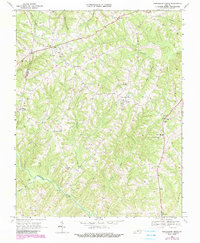
1968 Map of Republican Grove
USGS Topo · Published 1990About this map
The Banister River meanders through the southern portion of this landscape, anchoring a rural network of small communities and crossroads in Halifax and Pittsylvania counties. Small settlements like Republican Grove and Volens serve as central points for the surrounding agricultural area, which is heavily interspersed with family and community cemeteries. The presence of the Sydnor Jennings Sch and several country churches, including Clover Bottom Ch and Oak Ridge Ch, highlights the established social infrastructure of the mid-20th century. High points like Peters Hill overlook a terrain carved by numerous waterways, including Buffalo Creek and Childrey Creek. A pipeline and several utility towers, including a Lookout Tower near Volens, reflect the modernizing infrastructure as updated in the late 1980s purple revisions.
Find a feature on this map
35 named features on this map. Tap any name to fly to it.
Don’t see what you’re looking for? This feature index may not catch every label — zoom into the map to look around manually.
Map Details
Editions of this 1968 Republican Grove Map
3 editions found
Other maps of this area

1892 · Lynchburg
USGS Topo · 1:125,000

1892 · Appomattox
USGS Topo · 1:125,000

1947 · Roanoke
USGS Topo · 1:250,000

1953 · Greensboro
USGS Topo · 1:250,000

1954 · Greensboro
USGS Topo · 1:250,000

1954 · Halifax
USGS Topo · 1:62,500

1954 · Riceville
USGS Topo · 1:62,500

1956 · Brookneal
USGS Topo · 1:62,500

1956 · Gladys
USGS Topo · 1:62,500

1959 · Roanoke
USGS Topo · 1:250,000