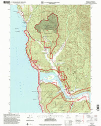
1997 Map of Requa
USGS Topo · Published 2001About this map
The Klamath River meets the Pacific Ocean in this coastal survey, highlighting the complex intersection of tribal, national, and state lands in late-century Del Norte County. The mouth of the river is flanked by the Yurok Indian Reservation and the Hoopa Valley Indian Reservation, with the Resighini rancheria situated on the south bank. Transportation and tourism landmarks are concentrated along the Redwood Highway, including the Louis P De Martin Sr Memorial Bridge and the Trees of Mystery attraction. Cultural sites like the Requa Cem and Keating School provide specific points of interest for genealogists tracing families in the settlements of Requa and Klamath. Higher elevations are defined by managed lands, including the Yurok Redwood Experimental Forest and the Klamath Air Force Station perched on the coastal bluffs.
Find a feature on this map
49 named features on this map. Tap any name to fly to it.
Don’t see what you’re looking for? This feature index may not catch every label — zoom into the map to look around manually.
Map Details
Editions of this 1997 Requa Map
This is the sole edition of this map. No revisions or reprints were ever made.
Other maps of this area

1922 · Preston Peak
USGS Topo · 1:125,000

1925 · Hoopa
USGS Topo · 1:125,000

1929 · Crescent City
USGS Topo · 1:125,000

1945 · Ship Mountain
USGS Topo · 1:62,500

1945 · Orick
USGS Topo · 1:62,500

1945 · Requa
USGS Topo · 1:62,500

1945 · Tectah Creek
USGS Topo · 1:62,500

1948 · Weed
USGS Topo · 1:250,000

1949 · Eureka
USGS Topo · 1:250,000

1950 · Weed
USGS Topo · 1:250,000