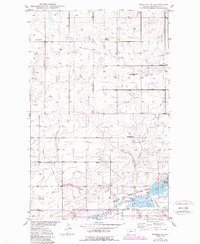
1948 Map of Reserve SE
USGS Topo · Published 1989About this map
Medicine Lake National Wildlife Refuge dominates the southern landscape of this Sheridan County survey, showing a complex system of water management within the prairie pothole region. This area, mapped between 1946 and 1948 with later revisions, reveals a rural economy transitioning from early homesteading to a more regulated agricultural and conservationist layout. The presence of numerous structures like Dam No 11 and Dam No 12 along Sand Creek and Cottonwood Creek highlights the critical role of water control in this high-plains environment.
Find a feature on this map
21 named features on this map. Tap any name to fly to it.
Don’t see what you’re looking for? This feature index may not catch every label — zoom into the map to look around manually.
Map Details
Editions of this 1948 Reserve SE Map
2 editions found
Other maps of this area

1946 · Dagmar
USGS Topo · 1:24,000

1947 · Capeneys Lake
USGS Topo · 1:24,000

1948 · Capeneys Lake
USGS Topo · 1:24,000

1948 · Dagmar
USGS Topo · 1:24,000

1948 · Reserve SE
USGS Topo · 1:24,000

1948 · Sunnyhill School
USGS Topo · 1:24,000

1948 · Medicine Lake
USGS Topo · 1:24,000

1948 · Reserve
USGS Topo · 1:24,000

1948 · Antelope
USGS Topo · 1:24,000

1949 · Reserve SE
USGS Topo · 1:24,000