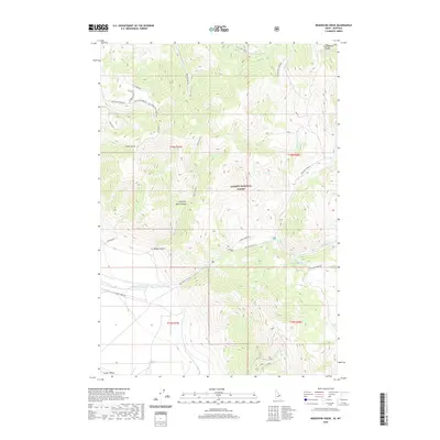
2020 Map of Reservoir Creek
USGS Topo · Published 2020About this map
The Continental Divide defines the eastern boundary of this high-altitude landscape, marking the rugged transition between the Salmon National Forest and the upper reaches of the Lemhi Valley. This 2020 survey documents a complex network of forest roads and drainages, including Salt Creek Rd and Hawley Creek Rd, which provide access to vital communication infrastructure like the Salt Creek Electronic Site and the Salt Creek Repeater. The terrain is deeply dissected by steep-walled features such as Rocky Canyon, Left Fork Rock Canyon, and Cedar Gulch. Numerous watercourses, including Salt Creek, Hawley Cr, and Reservoir Cr, drain these canyons, illustrating the watershed patterns that have long governed movement through this section of the Idaho-Montana borderlands.
Find a feature on this map
31 named features on this map. Tap any name to fly to it.
Don’t see what you’re looking for? This feature index may not catch every label — zoom into the map to look around manually.
Map Details
Editions of this 2020 Reservoir Creek Map
This is the sole edition of this map. No revisions or reprints were ever made.
Other maps of this area

1955 · Dubois
USGS Topo · 1:250,000

1956 · Leadore
USGS Topo · 1:62,500

1956 · Morrison Lake
USGS Topo · 1:62,500

1958 · Dubois
USGS Topo · 1:250,000

1965 · Deadman Pass
USGS Topo · 1:24,000

1965 · Bannock Pass
USGS Topo · 1:24,000
1965 · Medicine Lodge Peak
USGS Topo · 1:24,000

1980 · Leadore
USGS Topo · 1:100,000
1987 · Morrison Lake
USGS Topo · 1:24,000

1987 · Purcell Spring
USGS Topo · 1:24,000