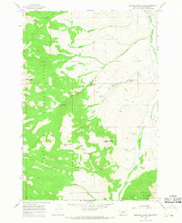
1965 Map of Medicine Lodge Peak
USGS Topo · Published 1968About this map
Beaverhead National Forest defines this high-elevation landscape in the mid-1960s, where the drainages of the Medicine Lodge Creek valley meet the steep divides of the Tendoy Mountains. The map documents a rugged water-management system centered around the Keystone Reservoir Spillway, supported by a network of seasonal water sources including Lake Canyon Spring and Shooting Herders Spring. This area reflects a mid-century period of land use where resource extraction and livestock management were the primary activities within the national forest boundaries.
Find a feature on this map
24 named features on this map. Tap any name to fly to it.
Don’t see what you’re looking for? This feature index may not catch every label — zoom into the map to look around manually.
Map Details
Editions of this 1965 Medicine Lodge Peak Map
2 editions found
Other maps of this area

1955 · Dubois
USGS Topo · 1:250,000

1956 · Morrison Lake
USGS Topo · 1:62,500

1958 · Dubois
USGS Topo · 1:250,000
1965 · Garfield Canyon
USGS Topo · 1:24,000

1965 · Deadman Pass
USGS Topo · 1:24,000

1965 · Jeff Davis Peak
USGS Topo · 1:24,000
1965 · Hansen Ranch
USGS Topo · 1:24,000

1965 · Graphite Mountain
USGS Topo · 1:24,000

1965 · Deer Canyon
USGS Topo · 1:24,000

1980 · Leadore
USGS Topo · 1:100,000