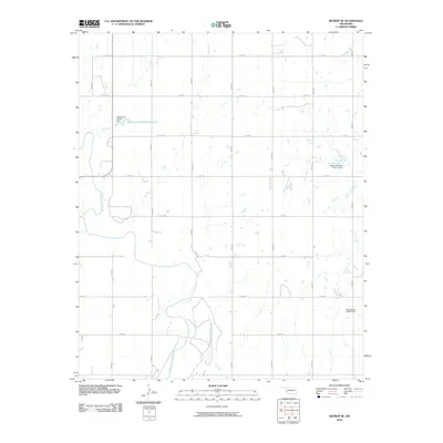
2010 Map of Retrop SE
USGS Topo · Published 2010About this map
The North Fork Red River meanders through this portion of Oklahoma, carving a distinct path through the grid of agricultural section lines and rural roads. This 2010 survey captures a landscape defined by water management and land use, featuring several engineered structures such as the Oknoname 075001 Dam and the Upper Elk Creek Site 41 Dam. The terrain is partitioned by a dense network of local roads including E 1310 RD and N 2040 RD, reflecting the organized settlement patterns of the western plains. While the river provides the primary natural landmark, the numerous smaller impoundments like the Oknoname 075001 Reservoir indicate the vital role of local water storage for the surrounding rural territory.
Find a feature on this map
21 named features on this map. Tap any name to fly to it.
Don’t see what you’re looking for? This feature index may not catch every label — zoom into the map to look around manually.
Map Details
Editions of this 2010 Retrop SE Map
This is the sole edition of this map. No revisions or reprints were ever made.
Other maps of this area

1955 · Lawton
USGS Topo · 1:250,000

1955 · Clinton
USGS Topo · 1:250,000

1957 · Clinton
USGS Topo · 1:250,000

1961 · Hobart
USGS Topo · 1:62,500

1961 · Retrop
USGS Topo · 1:62,500

1964 · Lone Wolf
USGS Topo · 1:24,000

1971 · Granite
USGS Topo · 1:24,000

1971 · Lake Altus
USGS Topo · 1:24,000

1984 · Sentinel
USGS Topo · 1:24,000
1984 · Cambridge
USGS Topo · 1:24,000