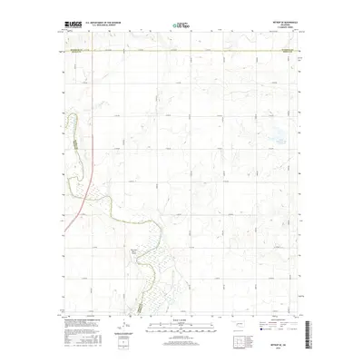
2016 Map of Retrop SE
USGS Topo · Published 2016About this map
The North Fork Red River creates a meandering natural boundary along the western edge of this Oklahoma landscape, where the borders of Beckham, Washita, Greer, and Kiowa Counties converge. The terrain is defined by a strict section-line road grid, including CO Line Rd and Boundary St, which overlays a topography of rolling drainage patterns. Aviation and water management are the primary modern landmarks, evidenced by the Twin Lakes Ranch Airport situated near the river's bend and the Upper Elk Creek Site 41 Reservoir in the northeast. This 2016 survey illustrates the persistent agricultural and ranching layout of the region, where infrastructure is sparsely distributed across a landscape shaped by the erosive path of the Red River system.
Find a feature on this map
24 named features on this map. Tap any name to fly to it.
Don’t see what you’re looking for? This feature index may not catch every label — zoom into the map to look around manually.
Map Details
Editions of this 2016 Retrop SE Map
This is the sole edition of this map. No revisions or reprints were ever made.
Other maps of this area

1955 · Lawton
USGS Topo · 1:250,000

1955 · Clinton
USGS Topo · 1:250,000

1957 · Clinton
USGS Topo · 1:250,000

1961 · Hobart
USGS Topo · 1:62,500

1961 · Retrop
USGS Topo · 1:62,500

1964 · Lone Wolf
USGS Topo · 1:24,000

1971 · Granite
USGS Topo · 1:24,000

1971 · Lake Altus
USGS Topo · 1:24,000

1984 · Sentinel
USGS Topo · 1:24,000
1984 · Cambridge
USGS Topo · 1:24,000