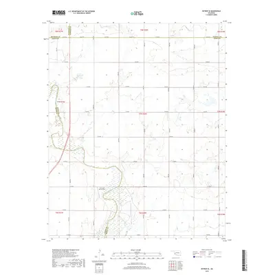
2018 Map of Retrop SE
USGS Topo · Published 2018About this map
The North Fork Red River meanders across this landscape, defining the intersection of several Oklahoma jurisdictions including the borders for Beckham, Washita, Greer, and Kiowa counties. This 2018 survey reveals a terrain organized by a rigid grid of rural roads, such as E1310 Rd and N2050 Rd, which cut across the natural hydrology of the river basin. The map documents a sparsely populated area where large-scale land use is punctuated by the Twin Lakes Ranch Airport and the 075001 Reservoir. The transition from the river's riparian edges to the elevated plains is clearly marked by contour lines, showing the relationship between the water's path and the agricultural road network of the High Plains.
Find a feature on this map
34 named features on this map. Tap any name to fly to it.
Don’t see what you’re looking for? This feature index may not catch every label — zoom into the map to look around manually.
Map Details
Editions of this 2018 Retrop SE Map
This is the sole edition of this map. No revisions or reprints were ever made.
Other maps of this area

1955 · Lawton
USGS Topo · 1:250,000

1955 · Clinton
USGS Topo · 1:250,000

1957 · Clinton
USGS Topo · 1:250,000

1961 · Hobart
USGS Topo · 1:62,500

1961 · Retrop
USGS Topo · 1:62,500

1964 · Lone Wolf
USGS Topo · 1:24,000

1971 · Granite
USGS Topo · 1:24,000

1971 · Lake Altus
USGS Topo · 1:24,000

1984 · Sentinel
USGS Topo · 1:24,000
1984 · Cambridge
USGS Topo · 1:24,000