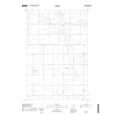
2017 Map of Revere
USGS Topo · Published 2017About this map
Revere serves as the central point of this Griggs County landscape, situated where the grid of prairie roads meets the meandering course of Baldhill Creek. The terrain is defined by its agricultural layout, with a dense network of sectional roads such as 102nd Ave SE and 4th St SE providing access to the fertile North Dakota plains. The survey illustrates the hydrography of the region, specifically how Baldhill Creek winds through the northern sections, creating a distinct break in the otherwise rigid township and range system. This map captures the modern rural infrastructure of the area, including vital local connectors like Co Rd 9 and Co Rd 11, reflecting the long-term settlement patterns and land management in the eastern part of the state.
Find a feature on this map
23 named features on this map. Tap any name to fly to it.
Don’t see what you’re looking for? This feature index may not catch every label — zoom into the map to look around manually.
Map Details
Editions of this 2017 Revere Map
This is the sole edition of this map. No revisions or reprints were ever made.
Other maps of this area

1952 · New Rockford
USGS Topo · 1:250,000

1956 · New Rockford
USGS Topo · 1:250,000

1961 · Sutton
USGS Topo · 1:24,000

1961 · Revere
USGS Topo · 1:24,000

1961 · Wimbledon
USGS Topo · 1:24,000

1961 · Hannaford
USGS Topo · 1:24,000

1961 · Wimbledon NE
USGS Topo · 1:24,000

1961 · Cooperstown West
USGS Topo · 1:24,000

1961 · Sutton NE
USGS Topo · 1:24,000
1961 · Sutton SW
USGS Topo · 1:24,000