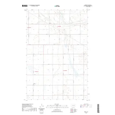
2020 Map of Revere
USGS Topo · Published 2020About this map
Baldhill Creek winds through the northern landscape of this Griggs County quadrangle, carving a distinct valley through the section lines of the rural prairie. The settlement of Revere sits at the intersection of 4th St SE and 104th Ave SE, serving as a central point in this highly organized agricultural grid. To the southwest, the Eidfjord Lutheran Cem stands as a significant local landmark for genealogical research, anchoring the history of the surrounding farming community. The map reveals an intricate network of township roads, such as Co Rd 9 and 107th Ave SE, which define the land use and accessibility of the region. This 2020 survey illustrates a modern snapshot of a classic North Dakota landscape where water drainage patterns like Baldhill Cr continue to influence the placement of homesteads and transportation routes.
Find a feature on this map
26 named features on this map. Tap any name to fly to it.
Don’t see what you’re looking for? This feature index may not catch every label — zoom into the map to look around manually.
Map Details
Editions of this 2020 Revere Map
This is the sole edition of this map. No revisions or reprints were ever made.
Other maps of this area

1952 · New Rockford
USGS Topo · 1:250,000

1956 · New Rockford
USGS Topo · 1:250,000

1961 · Sutton
USGS Topo · 1:24,000

1961 · Revere
USGS Topo · 1:24,000

1961 · Wimbledon
USGS Topo · 1:24,000

1961 · Hannaford
USGS Topo · 1:24,000

1961 · Wimbledon NE
USGS Topo · 1:24,000

1961 · Cooperstown West
USGS Topo · 1:24,000

1961 · Sutton NE
USGS Topo · 1:24,000
1961 · Sutton SW
USGS Topo · 1:24,000