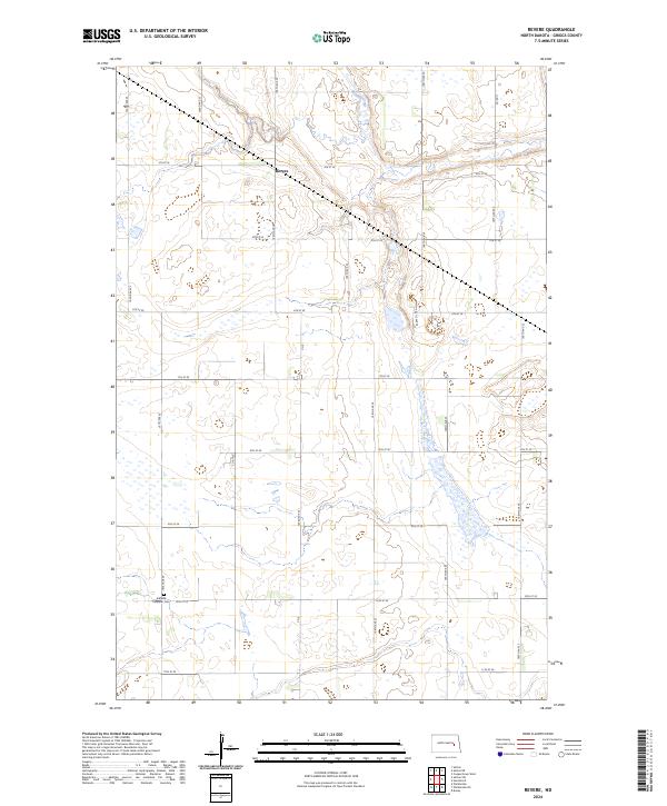
2024 Map of Revere
USGS Topo · Published 2024About this map
Revere sits as the central point of this agricultural landscape in Griggs County, where the geometric precision of the Public Land Survey System meets the natural wanderings of Baldhill Creek. The creek valley cuts a distinct path through the township divisions of t145n r60w and t144n r60w, creating a varied topography contrasted against the surrounding grid of section lines and gravel roads. For those tracing family roots, the Eidsfjord Lutheran Cem stands as a significant landmark in the southwestern portion of the map, preserved amidst the cultivated fields. Much of the terrain is dedicated to the Griggs County Waterfowl Production Area, which encompasses numerous small prairie potholes and wetlands. These protected areas follow the natural depressions of the land, illustrating the persistent character of the North Dakota prairie even as modern road networks like Co Rd 9 and 104th Ave SE define the contemporary movement of goods and people.
Find a feature on this map
27 named features on this map. Tap any name to fly to it.
Don’t see what you’re looking for? This feature index may not catch every label — zoom into the map to look around manually.
Map Details
Editions of this 2024 Revere Map
This is the sole edition of this map. No revisions or reprints were ever made.
Other maps of this area

1952 · New Rockford
USGS Topo · 1:250,000

1956 · New Rockford
USGS Topo · 1:250,000

1961 · Sutton
USGS Topo · 1:24,000

1961 · Revere
USGS Topo · 1:24,000

1961 · Wimbledon
USGS Topo · 1:24,000

1961 · Hannaford
USGS Topo · 1:24,000

1961 · Wimbledon NE
USGS Topo · 1:24,000

1961 · Cooperstown West
USGS Topo · 1:24,000

1961 · Sutton NE
USGS Topo · 1:24,000
1961 · Sutton SW
USGS Topo · 1:24,000