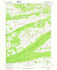
1959 Map of Reward
USGS Topo · Published 1979About this map
Berry Mountain and Buffalo Mountain anchor the southern reaches of this landscape, defining a series of narrow, parallel valleys characteristic of the Ridge-and-Valley Appalachians. The settlement pattern follows these lowlands, with small communities like Nekoda and Centerville connected by winding roads that skirt the steep slopes of Turkey Ridge and Wild Cat Ridge. Numerous country churches and cemeteries, including St Michaels Ch and Reward Cem, are scattered throughout the Foutz Valley and Greenwood Valley, serving as historical markers for the rural families of Perry County. The northeastern corner touches the Susquehanna Valley, where Liverpool sits near the river's edge. Waterways such as Cocolamus Creek and Turkey Run drain these interior basins, while the Juniata-Perry county line cuts across the northern ridges, marking a political boundary through the forested terrain.
Find a feature on this map
45 named features on this map. Tap any name to fly to it.
Don’t see what you’re looking for? This feature index may not catch every label — zoom into the map to look around manually.
Map Details
Editions of this 1959 Reward Map
4 editions found
Other maps of this area

1892 · Harrisburg
USGS Topo · 1:62,500

1893 · Millersburg
USGS Topo · 1:62,500

1899 · Harrisburg
USGS Topo · 1:62,500

1907 · New Bloomfield
USGS Topo · 1:62,500

1907 · Millerstown
USGS Topo · 1:62,500

1924 · Harrisburg
USGS Topo · 1:62,500

1943 · Millerstown
USGS Topo · 1:62,500

1943 · Millersburg
USGS Topo · 1:62,500

1943 · Harrisburg
USGS Topo · 1:62,500

1943 · New Bloomfield
USGS Topo · 1:62,500
Featured Places
- Greenwood Township, PA
- Greenwood Township, PA
- Buffalo Township, PA
- Howe Township, PA
- Centerville, Liverpool Township