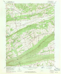
1959 Map of Reward
USGS Topo · Published 1971About this map
The linear ridges of Perry and Juniata counties define a landscape of secluded valleys and rural hamlets in this mid-century survey. Greenwood Valley and Foutz Valley stretch between the high points of Turkey Ridge and Wildcat Ridge, where settlement is clustered around crossroads and small country congregations. The map documents numerous spiritual and community centers like Pfoutz Valley Ch, St Michaels Ch, and St Matthews Ch, reflecting the deep-rooted German and Scotch-Irish heritage typical of this region.
Find a feature on this map
45 named features on this map. Tap any name to fly to it.
Don’t see what you’re looking for? This feature index may not catch every label — zoom into the map to look around manually.
Map Details
Editions of this 1959 Reward Map
4 editions found
Other maps of this area

1892 · Harrisburg
USGS Topo · 1:62,500

1893 · Millersburg
USGS Topo · 1:62,500

1899 · Harrisburg
USGS Topo · 1:62,500

1907 · New Bloomfield
USGS Topo · 1:62,500

1907 · Millerstown
USGS Topo · 1:62,500

1924 · Harrisburg
USGS Topo · 1:62,500

1943 · Millerstown
USGS Topo · 1:62,500

1943 · Millersburg
USGS Topo · 1:62,500

1943 · Harrisburg
USGS Topo · 1:62,500

1943 · New Bloomfield
USGS Topo · 1:62,500
Featured Places
- Greenwood Township, PA
- Greenwood Township, PA
- Buffalo Township, PA
- Howe Township, PA
- Centerville, Liverpool Township