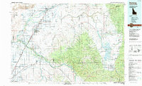
1988 Map of Rexburg
USGS Topo · Published 1989About this map
Rexburg and the surrounding Snake River Plain appear here as a landscape defined by an intricate network of irrigation canals like the Egin Bench Canal and Farmers Friend Canal. The map details the region's agricultural infrastructure during the late 1980s, shortly after the reconstruction following the Teton Dam failure. The Teton River flows westward to meet the Henry Fork, while the South Fork Snake River carves the southern border near the Ririe Reservoir. Higher elevations rise to the east with the Big Hole Mountains and the Snake River Range within the Targhee National Forest. Local civic and educational life is anchored by Ricks College and the Madison County Courthouse. The Union Pacific Railroad serves as the primary industrial artery, connecting settlements from Saint Anthony down through Sugar City and Thornton.
Find a feature on this map
144 named features on this map. Tap any name to fly to it.
Don’t see what you’re looking for? This feature index may not catch every label — zoom into the map to look around manually.
Map Details
Editions of this 1988 Rexburg Map
This is the sole edition of this map. No revisions or reprints were ever made.
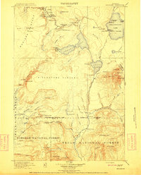
Other maps of this area

1886 · Shoshone
USGS Topo · 1:125,000

1888 · Shoshone
USGS Topo · 1:125,000

1895 · Shoshone
USGS Topo · 1:125,000

1899 · Grand Teton
USGS Topo · 1:125,000

1901 · Shoshone
USGS Topo · 1:125,000

1901 · Grand Teton
USGS Topo · 1:125,000

1908 · Shoshone
USGS Topo · 1:125,000
1911 · Shoshone
USGS Topo · 1:125,000

1924 · Hell Creek
USGS Topo · 1:62,500

1924 · Ammon
USGS Topo · 1:62,500