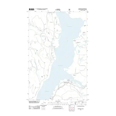
2011 Map of Rexford
USGS Topo · Published 2011About this map
Lake Koocanusa dominates the central landscape of this northern Montana terrain, where the Tobacco River flows into the reservoir just east of the settlement of Rexford. The area is a significant corridor for recreation and local industry, featuring the Murray Springs State Fish Hatchery and several shoreline destinations like the Rexford Bench Campground and Tobacco Plains Boat Ramp. The town of Rexford itself serves as a focal point for the community, housing the Rexford Post Office near the junction of Hayden St and the reservoir's edge. Residential developments such as Koocanusa Estates and the waterfront community at Mariners Haven reflect the modern settlement patterns centered on the lake. Further inland, the geography is defined by a network of small water bodies, including Swisher Lake, Sophie Lake, and Madden Lake, alongside named topographical landmarks like Olsen Hill and Sand Hill.
Find a feature on this map
53 named features on this map. Tap any name to fly to it.
Don’t see what you’re looking for? This feature index may not catch every label — zoom into the map to look around manually.
Map Details
Editions of this 2011 Rexford Map
This is the sole edition of this map. No revisions or reprints were ever made.
Other maps of this area

1957 · Kalispell
USGS Topo · 1:250,000

1960 · Kalispell
USGS Topo · 1:250,000

1961 · Kalispell
USGS Topo · 1:250,000

1963 · Rexford
USGS Topo · 1:24,000

1963 · Eureka North
USGS Topo · 1:24,000

1963 · Eureka South
USGS Topo · 1:24,000

1963 · Red Mountain
USGS Topo · 1:24,000

1963 · Webb Mountain
USGS Topo · 1:24,000
1963 · Beartrap Mountain
USGS Topo · 1:24,000

1979 · Yaak River
USGS Topo · 1:100,000