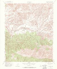
1943 Map of Reyes Peak
USGS Topo · Published 1967About this map
Los Padres National Forest dominates this 1940s survey of the Ventura County high country, where the landscape is defined by the massive ridge of Pine Mountain and its highest point at Reyes Peak. The terrain is characterized by a dense network of drainage systems, including West Fork Sespe Creek and Beartrap Creek, which carve deep through the forest toward the south. To the north, the Cuyama River provides a stark contrast as it winds through the broader canyon floors. Human presence is sparse in this wilderness area, centered primarily around Scheideck Camp and a handful of designated springs and corrals. The mapping reflects the intensive photogrammetric work performed by the Army Map Service during the war years, capturing the intricate topography of Snail Canyon, Dry Canyon, and the various forks of the Sespe Creek drainage system.
Find a feature on this map
25 named features on this map. Tap any name to fly to it.
Don’t see what you’re looking for? This feature index may not catch every label — zoom into the map to look around manually.
Map Details
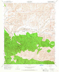
Editions of this 1943 Reyes Peak Map
3 editions found
Other maps of this area

1903 · Mt. Pinos
USGS Topo · 1:125,000

1942 · Wheeler Springs
USGS Topo · 1:24,000

1943 · Rancho Nuevo Creek
USGS Topo · 1:24,000

1943 · Old Man Mountain
USGS Topo · 1:24,000

1943 · Apache Canyon
USGS Topo · 1:24,000

1943 · San Guillermo
USGS Topo · 1:24,000

1943 · Sawmill Mountain
USGS Topo · 1:24,000

1943 · Cuyama Peak
USGS Topo · 1:24,000

1943 · Lion Canyon
USGS Topo · 1:24,000

1943 · Reyes Peak
USGS Topo · 1:24,000