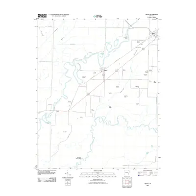
2011 Map of Reyno
USGS Topo · Published 2011About this map
Biggers and Reyno anchor this northeastern Arkansas landscape, where the winding courses of the Current River and Black River dictate the local geography. The area's history is preserved through a remarkable concentration of family and community burial grounds, including the Brimmage Cemetery, Scott Cemetery, and Hite Cemetery, which serve as vital markers for genealogical research. The transition from the original settlement at Old Reyno to the newer townsite is visible, alongside evidence of early river commerce at Richardson Ferry and Jim Johnson Landing.
Find a feature on this map
69 named features on this map. Tap any name to fly to it.
Don’t see what you’re looking for? This feature index may not catch every label — zoom into the map to look around manually.
Map Details
Editions of this 2011 Reyno Map
This is the sole edition of this map. No revisions or reprints were ever made.
Other maps of this area

1932 · Walnut Ridge
USGS Topo · 1:62,500

1935 · Knobel
USGS Topo · 1:62,500

1935 · Reyno
USGS Topo · 1:62,500

1935 · Walnut Ridge
USGS Topo · 1:62,500

1940 · Gainesville
USGS Topo · 1:62,500

1941 · Knobel
USGS Topo · 1:62,500

1957 · Poplar Bluff
USGS Topo · 1:250,000

1958 · Gainesville
USGS Topo · 1:62,500

1959 · Poplar Bluff
USGS Topo · 1:250,000
1960 · Gainesville
USGS Topo · 1:62,500