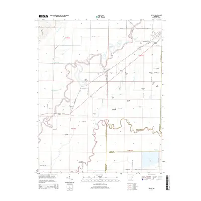
2014 Map of Reyno
USGS Topo · Published 2014About this map
Reyno and the nearby site of Old Reyno occupy a landscape defined by the winding course of the Current River and the meandering Black River. This 2014 survey reveals a territory structured by water, where oxbow lakes such as Peachtree Lake, Sumac Lake, and Gas Plant Lake trace former river channels. The drainage network is further refined by man-made engineering, visible in the numbered laterals like Lateral Number 4 and Lateral Number 5 that grid the agricultural fields of Randolph Co.
Find a feature on this map
93 named features on this map. Tap any name to fly to it.
Don’t see what you’re looking for? This feature index may not catch every label — zoom into the map to look around manually.
Map Details
Editions of this 2014 Reyno Map
This is the sole edition of this map. No revisions or reprints were ever made.
Other maps of this area

1932 · Walnut Ridge
USGS Topo · 1:62,500

1935 · Knobel
USGS Topo · 1:62,500

1935 · Reyno
USGS Topo · 1:62,500

1935 · Walnut Ridge
USGS Topo · 1:62,500

1940 · Gainesville
USGS Topo · 1:62,500

1941 · Knobel
USGS Topo · 1:62,500

1957 · Poplar Bluff
USGS Topo · 1:250,000

1958 · Gainesville
USGS Topo · 1:62,500

1959 · Poplar Bluff
USGS Topo · 1:250,000
1960 · Gainesville
USGS Topo · 1:62,500