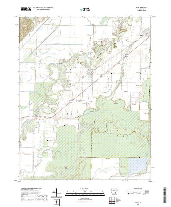
2024 Map of Reyno
USGS Topo · Published 2024About this map
The Current River and Black River dominate this low-lying landscape in Randolph and Clay counties, creating a complex network of wetlands and oxbows such as Sumac Lake and Schnabaum Lake. The interaction between the river systems and the local economy is evident in the numerous historic crossing points, including Scotts Ferry, Biggers Ferry, and Old McElroy Ferry. The settlement of Reyno stands in the northeast corner along the BNSF Railway, while Biggers sits central to the river bends, illustrating how rail and water defined early development patterns in the Arkansas Delta.
Find a feature on this map
93 named features on this map. Tap any name to fly to it.
Don’t see what you’re looking for? This feature index may not catch every label — zoom into the map to look around manually.
Map Details
Editions of this 2024 Reyno Map
This is the sole edition of this map. No revisions or reprints were ever made.
Other maps of this area

1932 · Walnut Ridge
USGS Topo · 1:62,500

1935 · Knobel
USGS Topo · 1:62,500

1935 · Reyno
USGS Topo · 1:62,500

1935 · Walnut Ridge
USGS Topo · 1:62,500

1940 · Gainesville
USGS Topo · 1:62,500

1941 · Knobel
USGS Topo · 1:62,500

1957 · Poplar Bluff
USGS Topo · 1:250,000

1958 · Gainesville
USGS Topo · 1:62,500

1959 · Poplar Bluff
USGS Topo · 1:250,000
1960 · Gainesville
USGS Topo · 1:62,500