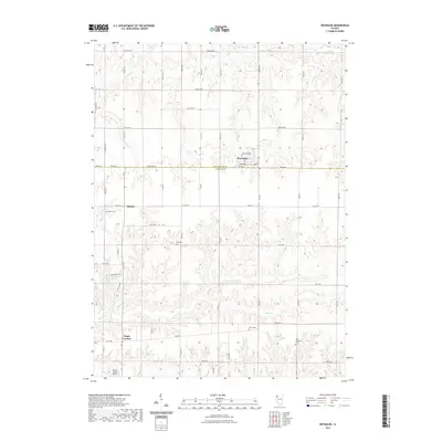
2021 Map of Reynolds
USGS Topo · Published 2021About this map
Reynolds sits at the intersection of Rock Island and Mercer Counties, serving as a primary settlement in this agricultural landscape. The terrain is defined by the winding paths of N Camp Cr and Camp Cr, which carve through the tillable acreage of western Illinois. For genealogists and local historians, the area is notably dense with small family or community burial grounds, including Reynolds Cem, Hamlet Cem, Gray Cem, Corns Cem, and Saint Josephs Cem, each marking long-established ties to the land. Settlement patterns follow a grid of county roads and named avenues, with Hamlet and Gingle Corners acting as smaller local hubs. The presence of the Mercer County Airport in the south and various drainage features like Illinois Slough and Copperas Cr illustrate the practical management of this prairie landscape for modern aviation and traditional farming.
Find a feature on this map
33 named features on this map. Tap any name to fly to it.
Don’t see what you’re looking for? This feature index may not catch every label — zoom into the map to look around manually.
Map Details
Editions of this 2021 Reynolds Map
This is the sole edition of this map. No revisions or reprints were ever made.
Other maps of this area

1912 · Milan
USGS Topo · 1:62,500

1916 · Edgington
USGS Topo · 1:62,500

1923 · Alexis
USGS Topo · 1:62,500

1925 · Alexis
USGS Topo · 1:62,500

1935 · Keithsburg
USGS Topo · 1:48,000

1938 · Edgington
USGS Topo · 1:62,500

1941 · Keithsburg
USGS Topo · 1:62,500

1944 · Milan
USGS Topo · 1:62,500
1948 · Milan
USGS Topo · 1:24,000

1950 · Milan
USGS Topo · 1:24,000