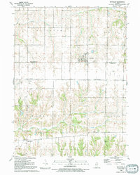
1991 Map of Reynolds
USGS Topo · Published 1992About this map
The village of Reynolds straddles the boundary between Rock Island and Mercer counties, serving as a central hub for the surrounding townships of Edgington, Bowling, Perryton, and Preemption. This early 1990s survey illustrates a landscape defined by agricultural regularity and natural drainage, with Camp Creek and its northern branches winding through the southern half of the quadrangle. Local road networks like Ridge Road and the Reynolds-Preemption Road connect the main settlement to smaller rural clusters such as Hamlet and Gingle Corners. For genealogical researchers, the map is remarkably dense with burial sites and rural houses of worship, ranging from the St Josephs and Warren cemeteries in the east to the Perryton Church and Corns Cemetery in the southwest. This detailed record of the late 20th-century countryside preserves the locations of numerous family-named landmarks and essential community centers before subsequent rural development.
Find a feature on this map
23 named features on this map. Tap any name to fly to it.
Don’t see what you’re looking for? This feature index may not catch every label — zoom into the map to look around manually.
Map Details
Editions of this 1991 Reynolds Map
This is the sole edition of this map. No revisions or reprints were ever made.
Other maps of this area

1912 · Milan
USGS Topo · 1:62,500

1916 · Edgington
USGS Topo · 1:62,500

1923 · Alexis
USGS Topo · 1:62,500

1925 · Alexis
USGS Topo · 1:62,500

1935 · Keithsburg
USGS Topo · 1:48,000

1938 · Edgington
USGS Topo · 1:62,500

1941 · Keithsburg
USGS Topo · 1:62,500

1944 · Milan
USGS Topo · 1:62,500
1948 · Milan
USGS Topo · 1:24,000

1950 · Milan
USGS Topo · 1:24,000