
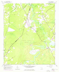
1943 Map of Rhems
USGS Topo · Published 1962About this map
The Black River meanders through the lowlands of South Carolina in this wartime survey, defining the border between Williamsburg and Georgetown Counties. This landscape is characterized by its extensive wetland systems, including the Black Steer Swamp, Mingo Swamp, and the large expanse of Gapway Bay. Settlement patterns follow the higher ground near the river and its many tributaries, such as Black Mingo Creek and Peters Creek, where community life centered around local landmarks like Antioch Ch and St Lukes Ch.
Find a feature on this map
39 named features on this map. Tap any name to fly to it.
Don’t see what you’re looking for? This feature index may not catch every label — zoom into the map to look around manually.
Map Details
Editions of this 1943 Rhems Map
2 editions found
Other maps of this area

1943 · Olin
USGS Topo · 1:31,680

1943 · Henry
USGS Topo · 1:24,000

1943 · Carvers Bay
USGS Topo · 1:24,000

1943 · Andrews
USGS Topo · 1:24,000

1943 · Georgetown North
USGS Topo · 1:24,000

1943 · Outland
USGS Topo · 1:24,000

1944 · Outland
USGS Topo · 1:31,680

1946 · Indiantown
USGS Topo · 1:62,500

1949 · Georgetown
USGS Topo · 1:250,000

1967 · Georgetown
USGS Topo · 1:250,000