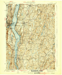
1939 Map of Rhinebeck
USGS Topo · Published 1939About this map
The Hudson River serves as the central artery for this 1930s landscape, dividing the riverfront communities of Kingston and Port Ewen on the west bank from the estates and rail stops of Dutchess County on the east. The dominance of the river-and-rail economy is evident in the parallel paths of the West Shore RR and the New York Central, which serviced ferry-connected landings like Rhinecliff and Sleightsburg. Inland, the terrain transitions into a patchwork of rural school districts and small hamlets like Schultzville and Netherwood, where the geography is defined by the winding Wappinger Creek and Landsman Kill. Religious and educational institutions are prominently marked, including St Josephs Sem near Ulster Park and St Andrews Seminary further south. From the Red Hook Golf Club in the north to the Landing Field near Rhinebeck, the map captures a period of early twentieth-century regional development before the expansion of modern highway systems.
Find a feature on this map
124 named features on this map. Tap any name to fly to it.
Don’t see what you’re looking for? This feature index may not catch every label — zoom into the map to look around manually.
Map Details
Editions of this 1939 Rhinebeck Map
3 editions found

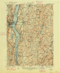
Other maps of this area

1892 · Kaaterskill
USGS Topo · 1:62,500

1893 · Kaaterskill
USGS Topo · 1:62,500

1893 · Clove
USGS Topo · 1:62,500

1893 · Poughkeepsie
USGS Topo · 1:62,500

1894 · Clove
USGS Topo · 1:62,500

1894 · Kaaterskill
USGS Topo · 1:62,500

1894 · Poughkeepsie
USGS Topo · 1:62,500

1895 · Catskill
USGS Topo · 1:62,500

1898 · Clove
USGS Topo · 1:62,500

1898 · Rhinebeck
USGS Topo · 1:62,500