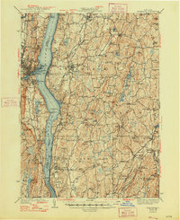
1939 Map of Rhinebeck
USGS Topo · Published 1948About this map
The Hudson River serves as the central artery for this mid-century landscape, separating the bustling industrial activity of Kingston and Rondout on the west bank from the rolling estates and farmland of Dutchess County to the east. Extensive rail infrastructure, including the New York Central RR and the West Shore RR, follows the river's edge, highlighting the corridor's role in the regional economy. Inland, the map reveals a network of tight-knit agricultural and mill communities such as De Witt Mills, Schultzville, and Pleasant Plains. The prevalence of small rural institutions like the Stone Ch, Ellerslie Sch, and Hook Sch provides a detailed look at the social geography of the 1930s, while large swampy tracts like Snyder Swamp and Lush Swamp remain largely undeveloped, defining the natural drainage patterns toward Wappinger Creek and Landsman Kill.
Find a feature on this map
131 named features on this map. Tap any name to fly to it.
Don’t see what you’re looking for? This feature index may not catch every label — zoom into the map to look around manually.
Map Details
Editions of this 1939 Rhinebeck Map
3 editions found

Other maps of this area

1892 · Kaaterskill
USGS Topo · 1:62,500

1893 · Kaaterskill
USGS Topo · 1:62,500

1893 · Clove
USGS Topo · 1:62,500

1893 · Poughkeepsie
USGS Topo · 1:62,500

1894 · Clove
USGS Topo · 1:62,500

1894 · Kaaterskill
USGS Topo · 1:62,500

1894 · Poughkeepsie
USGS Topo · 1:62,500

1895 · Catskill
USGS Topo · 1:62,500

1898 · Clove
USGS Topo · 1:62,500

1898 · Rhinebeck
USGS Topo · 1:62,500