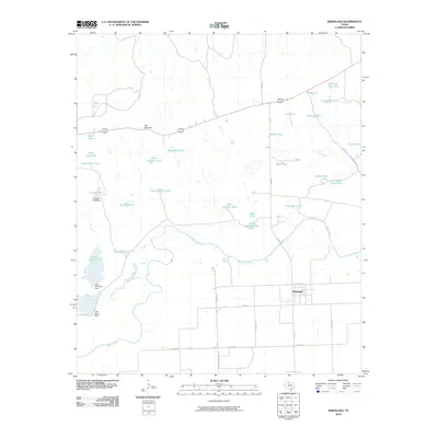
2010 Map of Rhineland
USGS Topo · Published 2010About this map
The Brazos River meanders across this landscape of Knox County, defining a region where water management is central to the land's utility. The unincorporated community of Rhineland sits just north of the river, served by a network of county roads like Co RD 4260 and secondary routes such as FM 2534. This area is characterized by an extensive system of man-made water features, including Lake Catharine and Lake Davis, which are essential for supporting the agricultural and ranching operations of north-central Texas.
Find a feature on this map
44 named features on this map. Tap any name to fly to it.
Don’t see what you’re looking for? This feature index may not catch every label — zoom into the map to look around manually.
Map Details
Editions of this 2010 Rhineland Map
This is the sole edition of this map. No revisions or reprints were ever made.
Other maps of this area

1954 · Wichita Falls
USGS Topo · 1:250,000

1958 · Wichita Falls
USGS Topo · 1:250,000

1966 · Truscott South
USGS Topo · 1:24,000

1966 · Gilliland
USGS Topo · 1:24,000

1966 · Vera
USGS Topo · 1:24,000

1967 · Hefner
USGS Topo · 1:24,000

1967 · Benjamin
USGS Topo · 1:24,000

1967 · Rhineland
USGS Topo · 1:24,000

1968 · Munday West
USGS Topo · 1:24,000
1968 · Munday East
USGS Topo · 1:24,000