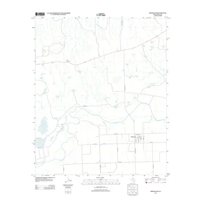
2013 Map of Rhineland
USGS Topo · Published 2013About this map
Rhineland stands as a focal point in this Knox County landscape, where a grid of rural roads meets the winding course of the Brazos River. The terrain is characterized by a high concentration of water management features, including dozens of stock tanks such as Ward Tank, Shipman Trap Tank, and Waggoner Tank, reflecting the ranching heritage of north-central Texas. Near the center of the sheet, the river passes through a distinctive geographical formation known as The Narrows, where the waterway creates a significant bend before continuing its southward journey toward larger reservoirs like Lake Catharine and Lake Davis. The map provides a clear picture of local land use, showing how county roads like Co RD 4260 and ranching infrastructure have adapted to the drainage patterns of Dutchman Cr and Red Cr.
Find a feature on this map
47 named features on this map. Tap any name to fly to it.
Don’t see what you’re looking for? This feature index may not catch every label — zoom into the map to look around manually.
Map Details
Editions of this 2013 Rhineland Map
This is the sole edition of this map. No revisions or reprints were ever made.
Other maps of this area

1954 · Wichita Falls
USGS Topo · 1:250,000

1958 · Wichita Falls
USGS Topo · 1:250,000

1966 · Truscott South
USGS Topo · 1:24,000

1966 · Gilliland
USGS Topo · 1:24,000

1966 · Vera
USGS Topo · 1:24,000

1967 · Hefner
USGS Topo · 1:24,000

1967 · Benjamin
USGS Topo · 1:24,000

1967 · Rhineland
USGS Topo · 1:24,000

1968 · Munday West
USGS Topo · 1:24,000
1968 · Munday East
USGS Topo · 1:24,000