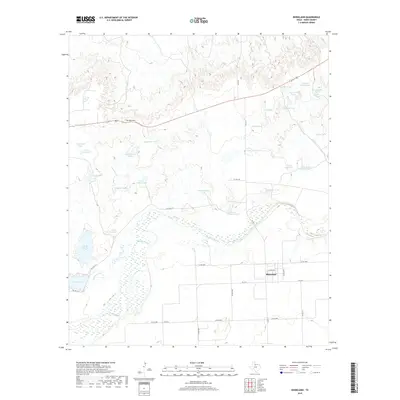
2019 Map of Rhineland
USGS Topo · Published 2019About this map
Rhineland occupies a high point in the southeast corner of this Knox County landscape, overlooking a complex system of drainage and water storage. The meandering course of the Brazos River dominates the central terrain, bordered by wide wetland zones and fed by seasonal tributaries like Dutchman Cr and Red Cr. To the north, a distinctive geological feature known as The Narrows provides a topographic bottleneck amidst the high plains.
Find a feature on this map
45 named features on this map. Tap any name to fly to it.
Don’t see what you’re looking for? This feature index may not catch every label — zoom into the map to look around manually.
Map Details
Editions of this 2019 Rhineland Map
This is the sole edition of this map. No revisions or reprints were ever made.
Other maps of this area

1954 · Wichita Falls
USGS Topo · 1:250,000

1958 · Wichita Falls
USGS Topo · 1:250,000

1966 · Truscott South
USGS Topo · 1:24,000

1966 · Gilliland
USGS Topo · 1:24,000

1966 · Vera
USGS Topo · 1:24,000

1967 · Hefner
USGS Topo · 1:24,000

1967 · Benjamin
USGS Topo · 1:24,000

1967 · Rhineland
USGS Topo · 1:24,000

1968 · Munday West
USGS Topo · 1:24,000
1968 · Munday East
USGS Topo · 1:24,000