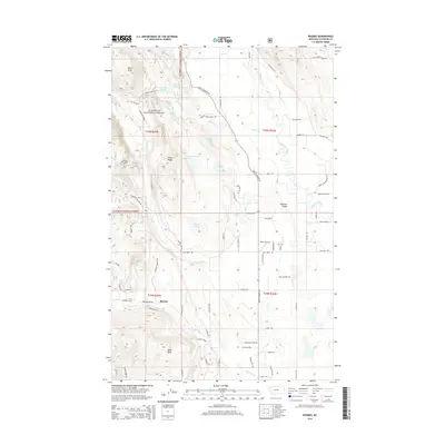
2014 Map of Rhodes
USGS Topo · Published 2014About this map
Rhodes and the broader Flathead Valley appear as a patchwork of small lakes and agricultural frontage in this 2014 survey. The Stillwater River meanders through the eastern portion of the map, carving a wide floodplain that transitions into the timbered slopes of the Flathead National Forest to the west. Landmarks like Bates Airstrip and numerous residential lane names, such as Sanctuary Farm Ln and Fox Farm Rd, suggest a landscape defined by rural homesteads and local aviation. The western heights are punctuated by Pilot Knob and Pete Ridge, overlooking a series of glacial depressions that hold Hanson-Doyle Lake, Bowser Lake, and Northwestern Lake. This specific alignment of terrain highlights the drainage patterns of Big Lost Cr and the geological formation known as Rhodes Draw, providing a clear record of the interface between the mountain foothills and the valley floor.
Find a feature on this map
51 named features on this map. Tap any name to fly to it.
Don’t see what you’re looking for? This feature index may not catch every label — zoom into the map to look around manually.
Map Details
Editions of this 2014 Rhodes Map
This is the sole edition of this map. No revisions or reprints were ever made.
Other maps of this area

1943 · Kalispell
USGS Topo · 1:125,000

1957 · Kalispell
USGS Topo · 1:250,000

1960 · Kalispell
USGS Topo · 1:250,000

1961 · Kalispell
USGS Topo · 1:250,000

1962 · Rose Crossing
USGS Topo · 1:24,000

1962 · Blue Grass Ridge
USGS Topo · 1:24,000

1962 · Beaver Lake
USGS Topo · 1:24,000

1962 · Lost Creek Divide
USGS Topo · 1:24,000

1962 · Rhodes
USGS Topo · 1:24,000
1962 · Kalispell
USGS Topo · 1:24,000