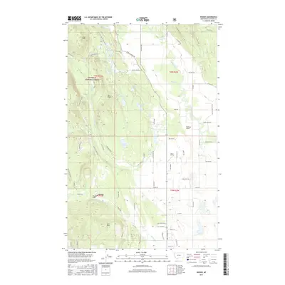
2017 Map of Rhodes
USGS Topo · Published 2017About this map
Flathead National Forest land meets the agriculture and homesteads of the Flathead Valley in this survey of the Montana landscape northwest of Kalispell. The terrain transitions from the high elevations of Pilot Knob and Pete Ridge in the west down toward the Stillwater River drainage in the east. The map reveals a high density of small water bodies and drainage systems, including Hanson-Doyle Lake, Bowser Lake, and the winding Big Lost Creek.
Find a feature on this map
74 named features on this map. Tap any name to fly to it.
Don’t see what you’re looking for? This feature index may not catch every label — zoom into the map to look around manually.
Map Details
Editions of this 2017 Rhodes Map
This is the sole edition of this map. No revisions or reprints were ever made.
Other maps of this area

1943 · Kalispell
USGS Topo · 1:125,000

1957 · Kalispell
USGS Topo · 1:250,000

1960 · Kalispell
USGS Topo · 1:250,000

1961 · Kalispell
USGS Topo · 1:250,000

1962 · Rose Crossing
USGS Topo · 1:24,000

1962 · Blue Grass Ridge
USGS Topo · 1:24,000

1962 · Beaver Lake
USGS Topo · 1:24,000

1962 · Lost Creek Divide
USGS Topo · 1:24,000

1962 · Rhodes
USGS Topo · 1:24,000
1962 · Kalispell
USGS Topo · 1:24,000