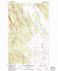
1991 Map of Rhodes
USGS Topo · Published 1995About this map
The Stillwater River meanders through the eastern portion of this landscape, defining a valley bordered by the rising terrain of the Stillwater State Forest and the Flathead National Forest. This 1991 snapshot of northwestern Montana reveals a community structure rooted in education and social gathering, evidenced by the Bissell Sch and the Northwest Flathead Community Hall. The terrain is punctuated by significant heights such as Pilot Knob and Pete Ridge, which look down upon a series of mountain lakes including Bowser Lake and Hanson-Doyle Lake. Drainage patterns like Tobie Creek and Lost Creek carve through the forested slopes, while the Ray Kuhns State Wildlife Management Area preserves the river bottomlands. This map is a record of the high-country settlements near Rhodes just as modern forest management and recreational land use became the primary drivers of the region.
Find a feature on this map
30 named features on this map. Tap any name to fly to it.
Don’t see what you’re looking for? This feature index may not catch every label — zoom into the map to look around manually.
Map Details
Editions of this 1991 Rhodes Map
This is the sole edition of this map. No revisions or reprints were ever made.
Other maps of this area

1943 · Kalispell
USGS Topo · 1:125,000

1957 · Kalispell
USGS Topo · 1:250,000

1960 · Kalispell
USGS Topo · 1:250,000

1961 · Kalispell
USGS Topo · 1:250,000

1962 · Rose Crossing
USGS Topo · 1:24,000

1962 · Blue Grass Ridge
USGS Topo · 1:24,000

1962 · Beaver Lake
USGS Topo · 1:24,000

1962 · Lost Creek Divide
USGS Topo · 1:24,000

1962 · Rhodes
USGS Topo · 1:24,000
1962 · Kalispell
USGS Topo · 1:24,000