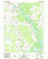
1988 Map of Rhodesdale
USGS Topo · Published 1988About this map
Marshyope Creek and the Nanticoke River define the eastern landscape of Dorchester County in this late-1980s topographic study. The map documents a rural network of small agricultural hubs like Rhodesdale, Eldorado, and Hurlock, connected by roads such as Osborne Road and Lecompte Road. The importance of the waterway to local life is evident in features like Ennalls Wharf and Walnut Landing, while the presence of McKendree Cem and Wesley Ch provide critical reference points for genealogical research.
Find a feature on this map
67 named features on this map. Tap any name to fly to it.
Don’t see what you’re looking for? This feature index may not catch every label — zoom into the map to look around manually.
Map Details
Editions of this 1988 Rhodesdale Map
This is the sole edition of this map. No revisions or reprints were ever made.
Other maps of this area

1901 · Salisbury
USGS Topo · 1:62,500

1903 · Nanticoke
USGS Topo · 1:62,500

1905 · Hurlock
USGS Topo · 1:62,500

1915 · Seaford
USGS Topo · 1:62,500

1942 · Mardela Springs
USGS Topo · 1:24,000

1942 · Hebron
USGS Topo · 1:24,000
1942 · Chicamacomico
USGS Topo · 1:24,000
1943 · Chicamacomico
USGS Topo · 1:31,680
1943 · Mardela Springs
USGS Topo · 1:31,680

1943 · Hebron
USGS Topo · 1:31,680