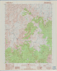
1987 Map of Rhyolite Ridge
USGS Topo · Published 1987About this map
The Silver Peak Range dominates this late-twentieth-century landscape, a high-desert environment defined by its water sources and mining legacy. The terrain is marked by significant topographical landmarks such as Rhyolite Ridge and Red Mountain, which provide the backdrop for scattered human activity. Water remains the critical factor for any enterprise here, evidenced by the presence of Minnesota Spring, North Spring, and Valcalda Springs.
Find a feature on this map
16 named features on this map. Tap any name to fly to it.
Don’t see what you’re looking for? This feature index may not catch every label — zoom into the map to look around manually.
Map Details
Editions of this 1987 Rhyolite Ridge Map
This is the sole edition of this map. No revisions or reprints were ever made.
Other maps of this area

1898 · Silver Peak
USGS Topo · 1:125,000

1900 · Silver Peak
USGS Topo · 1:125,000

1908 · Lida
USGS Topo · 1:250,000

1913 · Lida
USGS Topo · 1:250,000

1954 · Goldfield
USGS Topo · 1:250,000

1955 · Goldfield
USGS Topo · 1:250,000

1958 · Goldfield
USGS Topo · 1:250,000

1962 · Goldfield
USGS Topo · 1:250,000
1963 · Piper Peak
USGS Topo · 1:62,500

1963 · Silver Peak
USGS Topo · 1:62,500