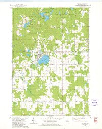
1949 Map of Rib Lake
USGS Topo · Published 1949About this map
Rib Lake stands as the primary hub of this landscape, situated at the confluence of several early transportation routes in central Wisconsin. The surrounding townships of Knox, Spirit, and Greenwood are characterized by a dense network of water bodies and small rural institutions that served the mid-century farming and timber communities. Numerous district schoolhouses, including Ring Sch, Fawn Valley Sch, and Rib River Sch, are scattered across the section lines, reflecting a decentralized pattern of early 20th-century rural life.
Find a feature on this map
72 named features on this map. Tap any name to fly to it.
Don’t see what you’re looking for? This feature index may not catch every label — zoom into the map to look around manually.
Map Details
Editions of this 1949 Rib Lake Map
This is the sole edition of this map. No revisions or reprints were ever made.
Historical Maps of Rib Lake Through Time
5 maps found