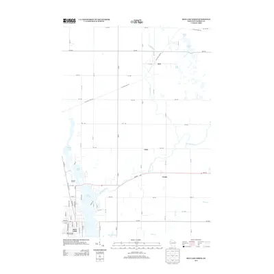
2013 Map of Rice Lake North
USGS Topo · Published 2013About this map
The Red Cedar River and its various tributaries define the landscape north of Rice Lake in this 2013 survey of Barron County. The terrain is a complex network of glacial remnants, featuring numerous water bodies such as Chain Lake, Goose Lake, and Tuscobia Lake. These natural features are intersected by a modern grid of rural avenues and the diagonal path of the Ice Age Natl Scenic Trl, which winds through the northern half of the quadrangle near the settlement of Brill. The map captures the transition from the city's northern edge, marked by the Rice Lake High School Stadium and the Indianhead Speedway, into the agricultural and wooded areas surrounding Dobie and Campia. This detailed study reflects the modern land use and transportation patterns in this part of Northwest Wisconsin.
Find a feature on this map
59 named features on this map. Tap any name to fly to it.
Don’t see what you’re looking for? This feature index may not catch every label — zoom into the map to look around manually.
Map Details
Editions of this 2013 Rice Lake North Map
This is the sole edition of this map. No revisions or reprints were ever made.
Other maps of this area

1949 · Rice Lake
USGS Topo · 1:48,000

1951 · Shell Lake
USGS Topo · 1:48,000

1951 · Rice Lake
USGS Topo · 1:48,000

1951 · Chetek
USGS Topo · 1:62,500

1951 · Barron
USGS Topo · 1:62,500

1953 · Rice Lake
USGS Topo · 1:250,000

1959 · Rice Lake
USGS Topo · 1:250,000

1965 · Rice Lake
USGS Topo · 1:62,500

1965 · Shell Lake
USGS Topo · 1:62,500
1978 · Barron
USGS Topo · 1:24,000