
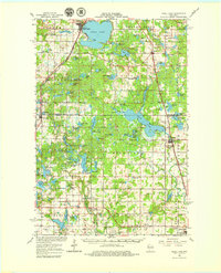
1965 Map of Shell Lake
USGS Topo · Published 1967About this map
The glacial lakes and wetlands of Washburn and Barron Counties are extensively mapped here in the mid-1960s, showing a landscape defined by the Chicago and North Western rail line and numerous conservation areas. The city of Shell Lake serves as a primary hub, featuring its municipal airport and proximity to the waters surrounding Scout Island. To the south, the Yellow River and Bear Lake State Wildlife Area highlight a shift toward land management and recreation, while scattered rural institutions like Heart Lake Church and the Section Ten School provide a look at the area's mid-century social fabric.
Find a feature on this map
107 named features on this map. Tap any name to fly to it.
Don’t see what you’re looking for? This feature index may not catch every label — zoom into the map to look around manually.
Map Details
Editions of this 1965 Shell Lake Map
2 editions found
Other maps of this area

1948 · Spooner
USGS Topo · 1:48,000

1948 · Stone Lake
USGS Topo · 1:48,000

1949 · Hertel
USGS Topo · 1:48,000

1949 · Spooner
USGS Topo · 1:48,000

1949 · Rice Lake
USGS Topo · 1:48,000

1950 · Stone Lake
USGS Topo · 1:48,000

1950 · Turtle Lake
USGS Topo · 1:62,500

1951 · Cumberland
USGS Topo · 1:48,000

1951 · Shell Lake
USGS Topo · 1:48,000

1951 · Rice Lake
USGS Topo · 1:48,000