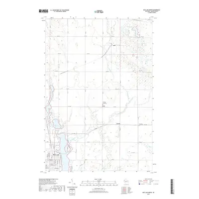
2018 Map of Rice Lake North
USGS Topo · Published 2018About this map
The northern edge of Rice Lake anchor this Barron County landscape, where the Red Cedar River flows through a series of glacial lakes and wetlands. The settlement pattern follows a grid of township avenues, connecting the small communities of Brill, Dobie, and Campia. Significant regional routes cross the terrain, including the Ice Age National Scenic Trail and the Wild Rivers State Trail, which occupies a former rail corridor. Local history is anchored by several rural church sites and burial grounds, such as Our Lady of Lourdes Catholic Cem and Our Saviors Lutheran Cem. The topography is defined by numerous smaller water bodies like Round Lake, Goose Lake, and Stump Lake, illustrating the complex glacial drainage typical of northern Wisconsin. The street plan of northern Rice Lake is detailed, showing residential growth near the northern shore of the reservoir.
Find a feature on this map
40 named features on this map. Tap any name to fly to it.
Don’t see what you’re looking for? This feature index may not catch every label — zoom into the map to look around manually.
Map Details
Editions of this 2018 Rice Lake North Map
This is the sole edition of this map. No revisions or reprints were ever made.
Other maps of this area

1949 · Rice Lake
USGS Topo · 1:48,000

1951 · Shell Lake
USGS Topo · 1:48,000

1951 · Rice Lake
USGS Topo · 1:48,000

1951 · Chetek
USGS Topo · 1:62,500

1951 · Barron
USGS Topo · 1:62,500

1953 · Rice Lake
USGS Topo · 1:250,000

1959 · Rice Lake
USGS Topo · 1:250,000

1965 · Rice Lake
USGS Topo · 1:62,500

1965 · Shell Lake
USGS Topo · 1:62,500
1978 · Barron
USGS Topo · 1:24,000