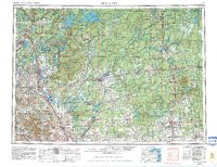
1953 Map of Rice Lake
USGS Topo · Published 1981About this map
The Chequamegon National Forest and the Lac Courte Oreilles Indian Reservation anchor the wooded landscape of northern Wisconsin. This mid-century survey reveals a region defined by its vast water systems, including the sprawling Lake Chippewa and the corridors of the Flambeau River and Chippewa River. Small industrial and timber towns like Ladysmith, Phillips, and Weyerhaeuser serve as nodes along the extensive rail network of the Soo Line and the Chicago and North Western.
Find a feature on this map
158 named features on this map. Tap any name to fly to it.
Don’t see what you’re looking for? This feature index may not catch every label — zoom into the map to look around manually.
Map Details
Editions of this 1953 Rice Lake Map
2 editions found

Other maps of this area

1902 · Marathon
USGS Topo · 1:125,000

1934 · Elk Mound
USGS Topo · 1:62,500

1934 · Chippewa Falls
USGS Topo · 1:62,500

1936 · Chippewa Falls
USGS Topo · 1:62,500

1936 · Elk Mound
USGS Topo · 1:62,500

1938 · Lac Du Flambeau
USGS Topo · 1:48,000

1939 · Lac Du Flambeau
USGS Topo · 1:48,000

1939 · Mc Cord
USGS Topo · 1:48,000

1939 · Winchester
USGS Topo · 1:48,000

1940 · Mercer
USGS Topo · 1:48,000