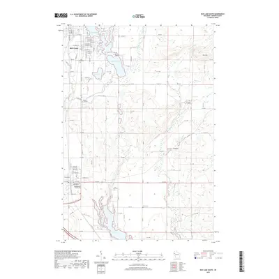
2018 Map of Rice Lake South
USGS Topo · Published 2018About this map
The Red Cedar River flows through this Barron County landscape, connecting a series of glacial water bodies including Rice Lake, Moon Lake, and Lake Montanis. The northern portion of the map is dominated by the southern reaches of the city of Rice Lake, where a dense grid of streets like E Sawyer St and W Coleman St transitions into the rural outskirts. Significant local history is preserved in numerous burial grounds, such as Saint Joseph Cem and Orchard Beach Cem, which overlook the lakefronts. To the south, the village of Cameron serves as a notable junction near the banks of Prairie Lake. The eastern horizon is shaped by the rising elevations of the Blue Hills, while the BNSF Railway provides a clear industrial corridor through the central valley, linking these lakeside settlements to the broader regional trade network.
Find a feature on this map
80 named features on this map. Tap any name to fly to it.
Don’t see what you’re looking for? This feature index may not catch every label — zoom into the map to look around manually.
Map Details
Editions of this 2018 Rice Lake South Map
This is the sole edition of this map. No revisions or reprints were ever made.
Other maps of this area

1949 · Rice Lake
USGS Topo · 1:48,000

1951 · Shell Lake
USGS Topo · 1:48,000

1951 · Rice Lake
USGS Topo · 1:48,000

1951 · Chetek
USGS Topo · 1:62,500

1951 · Barron
USGS Topo · 1:62,500

1953 · Rice Lake
USGS Topo · 1:250,000

1959 · Rice Lake
USGS Topo · 1:250,000

1965 · Rice Lake
USGS Topo · 1:62,500

1965 · Shell Lake
USGS Topo · 1:62,500
1978 · Barron
USGS Topo · 1:24,000