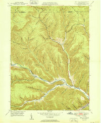
1950 Map of Rich Valley
USGS Topo · Published 1950About this map
Driftwood Branch Sinnemahoning Creek carves a deep valley through this portion of Cameron and McKean Counties, serving as the primary corridor for settlement and transit in an otherwise densely dissected upland. Small communities like Lockwood and Weber City cling to the narrow valley floor, where the confluence of numerous mountain runs creates room for small-scale development. The map reveals the social infrastructure of these rural hollows, including the North Creek Chapel and Swesey Sch, positioned near the junction of North Creek and the main branch. Away from the creek, the landscape is defined by a complex network of named drainages such as Oil Well Hollow and Hunting Shanty Run, many of which are accessed only by old trails. This 1950 survey represents the area just as aerial photogrammetry was beginning to refine the mapping of the Dividing Ridge and the steep terrain of Shippen and Norwich townships.
Find a feature on this map
58 named features on this map. Tap any name to fly to it.
Don’t see what you’re looking for? This feature index may not catch every label — zoom into the map to look around manually.
Map Details
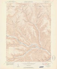
Editions of this 1950 Rich Valley Map
2 editions found
Other maps of this area

1941 · Benezette
USGS Topo · 1:62,500

1943 · Benezette
USGS Topo · 1:62,500

1945 · Driftwood
USGS Topo · 1:48,000

1945 · Cameron
USGS Topo · 1:24,000

1947 · Cameron
USGS Topo · 1:24,000

1948 · Crosby
USGS Topo · 1:62,500

1948 · Emporium
USGS Topo · 1:62,500

1948 · Keating Summit
USGS Topo · 1:24,000

1948 · Emporium
USGS Topo · 1:24,000

1948 · Wildwood Fire Tower
USGS Topo · 1:24,000
Featured Places
- Norwich Township, PA
- Weber City, Shippen Township
- Shippen Township, PA
- Lockwood, Shippen Township
- Lawn View, Shippen Township