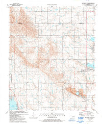
1991 Map of Richards Spur
USGS Topo · Published 1992About this map
The waters of Lake Ellsworth and Lake Lawtonka dominate the eastern and southwestern reaches of this Comanche County landscape, reflecting the region's 20th-century development of water resources. Between these reservoirs, the terrain is marked by the rugged heights of Stony Point and the presence of significant cultural sites including the Whitewolf Ceremonial Grounds and the Mountain Scott Tribal Cemetery. This map provides a clear picture of local infrastructure just before the turn of the millennium, showing the transition from extractive industry at the Quarry and its conveyor system to the growing residential communities of Edgewater Park and Green Meadow Acres. Historical community life is anchored by landmarks such as the Stony Point School, Paradise Valley Church, and the aviation footprint of the Leatherbury Landing Strip.
Find a feature on this map
33 named features on this map. Tap any name to fly to it.
Don’t see what you’re looking for? This feature index may not catch every label — zoom into the map to look around manually.
Map Details
Editions of this 1991 Richards Spur Map
This is the sole edition of this map. No revisions or reprints were ever made.
Other maps of this area

1937 · Cache
USGS Topo · 1:48,000

1942 · Cache
USGS Topo · 1:62,500

1946 · Lawton
USGS Topo · 1:62,500

1949 · Mount Scott
USGS Topo · 1:24,000

1949 · Arbuckle Hill
USGS Topo · 1:24,000

1949 · Elgin
USGS Topo · 1:24,000

1949 · Fort Sill
USGS Topo · 1:24,000

1950 · Saddle Mountain
USGS Topo · 1:62,500

1955 · Lawton
USGS Topo · 1:250,000

1956 · Arbuckle Hill
USGS Topo · 1:24,000