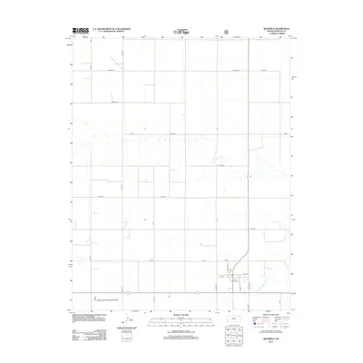
2012 Map of Richfield
USGS Topo · Published 2012About this map
Richfield sits at the heart of this southwestern Kansas landscape, positioned just north of the winding N Fork Cimarron River. The town's grid is clearly defined by local landmarks like the Post Office and streets such as Walnut St and Taylor Blvd. This 2012 survey illustrates a classic High Plains settlement pattern where a rigid sectional road network, including Co Road BB and Co Road X, overlays the natural drainage of the river basin. To the south, the map identifies New Pasture Number Thirteen, reflecting the regional emphasis on organized grazing and land management. The sparse distribution of named features highlights the open character of Morton County, where transportation corridors like Leader Blvd and BB Blvd connect isolated homesteads and ranching operations to the central village.
Find a feature on this map
28 named features on this map. Tap any name to fly to it.
Don’t see what you’re looking for? This feature index may not catch every label — zoom into the map to look around manually.
Map Details
Editions of this 2012 Richfield Map
This is the sole edition of this map. No revisions or reprints were ever made.
Other maps of this area

1955 · Dodge City
USGS Topo · 1:250,000

1958 · Dodge City
USGS Topo · 1:250,000

1959 · Dodge City
USGS Topo · 1:250,000

1973 · Richfield NW
USGS Topo · 1:24,000

1973 · Shore Airport SW
USGS Topo · 1:24,000

1973 · Shore Airport
USGS Topo · 1:24,000

1973 · Rolla NW
USGS Topo · 1:24,000

1973 · Richfield NE
USGS Topo · 1:24,000

1973 · Elkhart NE
USGS Topo · 1:24,000
1973 · Richfield SW
USGS Topo · 1:24,000