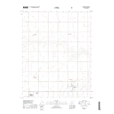
2018 Map of Richfield
USGS Topo · Published 2018About this map
Richfield serves as the primary hub of this high-plains landscape in Morton County, where a tidy grid of streets like Main St, Walnut St, and Oak St meets the open range. The town is flanked by the North Blvd and South Blvd corridors, marking a transition into the vast agricultural and conservation lands of southwestern Kansas. To the south, the topography descends toward the N Fork Cimarron River, a vital watercourse that defines the local drainage patterns. Portions of the Cimarron National Grassland occupy the southwestern corner of the map, highlighting the region's commitment to prairie preservation. The map also records specific land use designations like New Pasture Number Thirteen, reflecting the organized grazing and ranching economy that sustains the area.
Find a feature on this map
30 named features on this map. Tap any name to fly to it.
Don’t see what you’re looking for? This feature index may not catch every label — zoom into the map to look around manually.
Map Details
Editions of this 2018 Richfield Map
This is the sole edition of this map. No revisions or reprints were ever made.
Other maps of this area

1955 · Dodge City
USGS Topo · 1:250,000

1958 · Dodge City
USGS Topo · 1:250,000

1959 · Dodge City
USGS Topo · 1:250,000

1973 · Richfield NW
USGS Topo · 1:24,000

1973 · Shore Airport SW
USGS Topo · 1:24,000

1973 · Shore Airport
USGS Topo · 1:24,000

1973 · Rolla NW
USGS Topo · 1:24,000

1973 · Richfield NE
USGS Topo · 1:24,000

1973 · Elkhart NE
USGS Topo · 1:24,000
1973 · Richfield SW
USGS Topo · 1:24,000