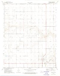
1973 Map of Richfield
USGS Topo · Published 1975About this map
Richfield stands as the primary hub of activity in this southwestern Kansas landscape, situated just north of the North Fork Cimarron River. The topography transitions from the river valley into a high plain marked by intensive energy exploration and agriculture. Dozens of Gas Wells and a Drill Hole punctuate the grid of section lines, reflecting the development of the Hugoton Gas Area during the early 1970s. North of the river, a Gaging Station monitors the water flow, while the settlement of Bradles and a local Gravel Pit indicate established rural infrastructure. This survey captures a moment when the regional economy was deeply tied to both the natural course of the Cimarron and the subterranean resources being tapped across the township.
Find a feature on this map
9 named features on this map. Tap any name to fly to it.
Don’t see what you’re looking for? This feature index may not catch every label — zoom into the map to look around manually.
Map Details
Editions of this 1973 Richfield Map
This is the sole edition of this map. No revisions or reprints were ever made.
Other maps of this area

1955 · Dodge City
USGS Topo · 1:250,000

1958 · Dodge City
USGS Topo · 1:250,000

1959 · Dodge City
USGS Topo · 1:250,000

1973 · Richfield NW
USGS Topo · 1:24,000

1973 · Shore Airport SW
USGS Topo · 1:24,000

1973 · Shore Airport
USGS Topo · 1:24,000

1973 · Rolla NW
USGS Topo · 1:24,000

1973 · Richfield NE
USGS Topo · 1:24,000

1973 · Elkhart NE
USGS Topo · 1:24,000
1973 · Richfield SW
USGS Topo · 1:24,000