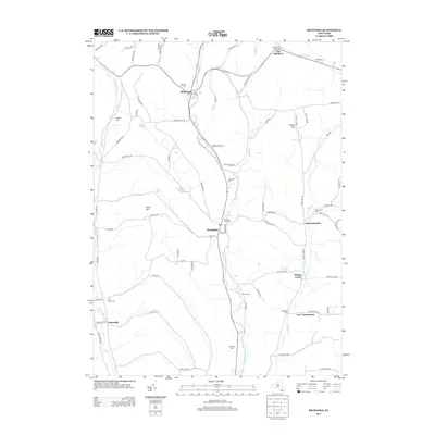
2013 Map of Richford
USGS Topo · Published 2013About this map
Richford and Berkshire anchor this section of Tioga County, where the valley of the E Br Owego Cr has long dictated the layout of roads and settlements. This 2013 survey illustrates a landscape of narrow agricultural valleys and high wooded ridges, including Nixon Hill and Turkey Hill. The distribution of historic burial grounds, such as Highland Cem and the Railroad Avenue Cem, points to the long-established hamlets that line the creek banks. Small agricultural holdings like Kingbird Farm and Stoughton Farm remain visible among the larger rural tracts. The presence of Railroad Ave in Berkshire serves as a modern reminder of the transportation infrastructure that once connected these dairy-farming communities to regional markets, while outlying areas like New Connecticut and Jenksville reflect the persistent character of southern New York's upland settlements.
Find a feature on this map
80 named features on this map. Tap any name to fly to it.
Don’t see what you’re looking for? This feature index may not catch every label — zoom into the map to look around manually.
Map Details
Editions of this 2013 Richford Map
This is the sole edition of this map. No revisions or reprints were ever made.
Other maps of this area

1900 · Dryden
USGS Topo · 1:62,500

1901 · Apalachin
USGS Topo · 1:62,500

1903 · Owego
USGS Topo · 1:62,500

1903 · Harford
USGS Topo · 1:62,500

1904 · Apalachin
USGS Topo · 1:62,500

1906 · Catatonk
USGS Topo · 1:125,000
1949 · Dryden
USGS Topo · 1:24,000

1949 · Speedsville
USGS Topo · 1:24,000
1949 · Harford
USGS Topo · 1:24,000
1949 · Lisle
USGS Topo · 1:24,000