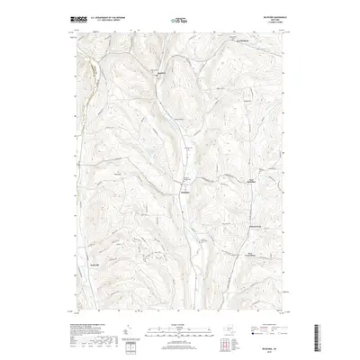
2019 Map of Richford
USGS Topo · Published 2019About this map
Richford and Berkshire anchor the valleys of the East Branch Owego Creek in this northern Tioga County landscape. The settlement pattern follows the north-south drainage, where older hamlets like East Richford and East Berkshire sit at the feet of high ridges such as Turkey Hill and Nixon Hill. Local genealogists will find several burial grounds mapped, including the Highland Cem near Richford and the Railroad Avenue Cem in Berkshire. The topography is deeply incised by tributaries like Dudley Cr and Wilson Cr, with the southwestern corner showing the smaller community of Jenksville near the Tompkins County line. A distinctive network of color-coded trails—labeled Blue, Red, and Yellow—indicates modern recreational use throughout the hilly terrain west of New Connecticut.
Find a feature on this map
81 named features on this map. Tap any name to fly to it.
Don’t see what you’re looking for? This feature index may not catch every label — zoom into the map to look around manually.
Map Details
Editions of this 2019 Richford Map
This is the sole edition of this map. No revisions or reprints were ever made.
Other maps of this area

1900 · Dryden
USGS Topo · 1:62,500

1901 · Apalachin
USGS Topo · 1:62,500

1903 · Owego
USGS Topo · 1:62,500

1903 · Harford
USGS Topo · 1:62,500

1904 · Apalachin
USGS Topo · 1:62,500

1906 · Catatonk
USGS Topo · 1:125,000
1949 · Dryden
USGS Topo · 1:24,000

1949 · Speedsville
USGS Topo · 1:24,000
1949 · Harford
USGS Topo · 1:24,000
1949 · Lisle
USGS Topo · 1:24,000