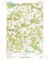
1968 Map of Richford
USGS Topo · Published 1990About this map
Richford serves as the central hub of this central Wisconsin landscape during the late 1960s, situated where the Mecan River and its various tributaries wind through the glacial topography. The area is defined by its numerous small kettle lakes and wetlands, including Fish Lake, Bobs Lake, and the spring-fed waters near Lake Virginia. Local civic life is anchored by several community landmarks, such as the Townhall and the Grace Ch, which is accompanied by the Grace Ch Cem. Youth recreation is also prominently featured, with the Merriam Boy Scout Camp and the American Legion Boys Camp both established on the shores of local lakes. To the northwest, the Greenwood State Wildlife Refuge occupies a significant portion of the terrain, indicating a regional focus on conservation and public land management. This survey provides a clear view of the rural road network and the distribution of farmsteads that supported the community before modern development.
Find a feature on this map
44 named features on this map. Tap any name to fly to it.
Don’t see what you’re looking for? This feature index may not catch every label — zoom into the map to look around manually.
Map Details
Editions of this 1968 Richford Map
2 editions found
Other maps of this area

1955 · Green Bay
USGS Topo · 1:250,000

1957 · Madison
USGS Topo · 1:250,000

1958 · Coloma
USGS Topo · 1:48,000

1959 · Wautoma
USGS Topo · 1:48,000

1960 · Madison
USGS Topo · 1:250,000

1961 · Oxford
USGS Topo · 1:62,500

1961 · Montello
USGS Topo · 1:62,500

1968 · Coloma
USGS Topo · 1:24,000

1968 · Richford
USGS Topo · 1:24,000

1968 · Plainfield
USGS Topo · 1:24,000