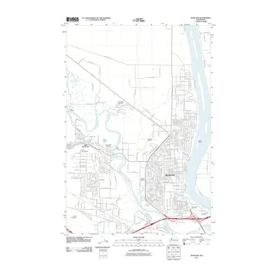
2011 Map of Richland
USGS Topo · Published 2011About this map
The Columbia River and Yakima River converge in this 2011 survey, defining the development of Richland and West Richland. The landscape reflects a mix of suburban growth and specialized land use, with numerous recreational spaces such as the Horn Rapids Desert Style Golf Course and Sham-na-pum Golf Course flanking the waterways. Residential expansion is evident in the dense street grids north of Aaron Dr, while the western edge remains marked by landmarks like Candy Mountain and Flat Top Hill. Local history is anchored by sites like Resthaven Cemetery and Sunset Memorial Gardens. Transport and irrigation infrastructure, including the Columbia Canal, Horn Rapids Ditch, and the Richland Airport, demonstrate how the region's geography has been managed to support its population and the legacy of the surrounding Tri-Cities area.
Find a feature on this map
241 named features on this map. Tap any name to fly to it.
Don’t see what you’re looking for? This feature index may not catch every label — zoom into the map to look around manually.
Map Details
Editions of this 2011 Richland Map
This is the sole edition of this map. No revisions or reprints were ever made.
Other maps of this area

1917 · Pasco
USGS Topo · 1:125,000

1951 · Richland
USGS Topo · 1:62,500

1953 · Walla Walla
USGS Topo · 1:250,000

1958 · Walla Walla
USGS Topo · 1:250,000

1964 · Kennewick
USGS Topo · 1:24,000

1964 · Pasco
USGS Topo · 1:62,500

1965 · Eltopia
USGS Topo · 1:62,500
1965 · Weber Canyon
USGS Topo · 1:24,000
1965 · Badger Mtn
USGS Topo · 1:24,000
1965 · Badger Mtn
USGS Topo · 1:62,500