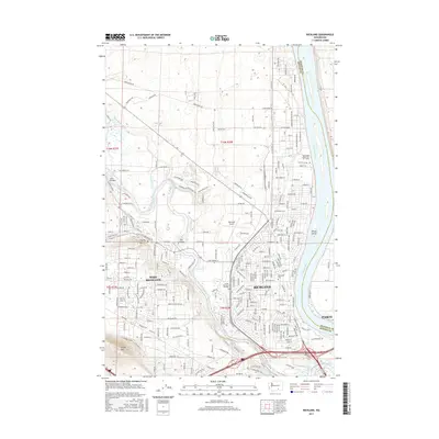
2017 Map of Richland
USGS Topo · Published 2017About this map
The confluence of the Columbia River and the Yakima River defines the landscape of this 2017 study of the Tri-Cities region. The urban footprints of Richland, West Richland, and a portion of Pasco are visible alongside the industrial and educational infrastructure that supports the area, including the Washington State Univ Tri - Cities campus and the Richland Airport. Significant irrigation and water management features like the Horn Rapids Ditch and the Columbia Canal reveal the transformation of this arid terrain into a productive river valley.
Find a feature on this map
122 named features on this map. Tap any name to fly to it.
Don’t see what you’re looking for? This feature index may not catch every label — zoom into the map to look around manually.
Map Details
Editions of this 2017 Richland Map
This is the sole edition of this map. No revisions or reprints were ever made.
Other maps of this area

1917 · Pasco
USGS Topo · 1:125,000

1951 · Richland
USGS Topo · 1:62,500

1953 · Walla Walla
USGS Topo · 1:250,000

1958 · Walla Walla
USGS Topo · 1:250,000

1964 · Kennewick
USGS Topo · 1:24,000

1964 · Pasco
USGS Topo · 1:62,500

1965 · Eltopia
USGS Topo · 1:62,500
1965 · Weber Canyon
USGS Topo · 1:24,000
1965 · Badger Mtn
USGS Topo · 1:24,000
1965 · Badger Mtn
USGS Topo · 1:62,500