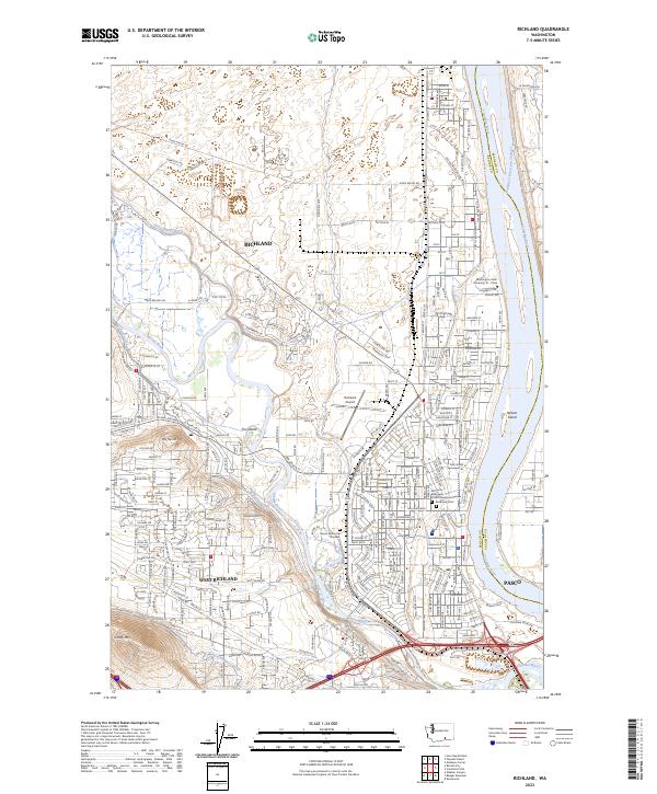
2023 Map of Richland
USGS Topo · Published 2023About this map
The confluence of the Columbia River and the Yakima River defines the landscape of this 21st-century Washington survey, where intensive irrigation and suburban development meet. The Columbia Canal and Horn Rapids Ditch snake through the terrain, supporting the agricultural footprint around Richland and West Richland. Local history is anchored by the All Saints Episcopal Church Memorial Garden and cemeteries like Resthaven Cem and Sunset Memorial Gardens, while the presence of Washington State University Tri - Cities marks the area's modern educational role. To the northeast, the McNary National Wildlife Refuge preserves the riparian environment along the Columbia, contrasting with the structured grid of the Richland Airport and the expanding residential corridors. Distinctive natural landmarks such as Candy Mtn and Flat Top Hill rise above the basin, providing a clear view of how water management has transformed the desert floor into a settled river hub.
Find a feature on this map
39 named features on this map. Tap any name to fly to it.
Don’t see what you’re looking for? This feature index may not catch every label — zoom into the map to look around manually.
Map Details
Editions of this 2023 Richland Map
This is the sole edition of this map. No revisions or reprints were ever made.
Other maps of this area

1917 · Pasco
USGS Topo · 1:125,000

1951 · Richland
USGS Topo · 1:62,500

1953 · Walla Walla
USGS Topo · 1:250,000

1958 · Walla Walla
USGS Topo · 1:250,000

1964 · Kennewick
USGS Topo · 1:24,000

1964 · Pasco
USGS Topo · 1:62,500

1965 · Eltopia
USGS Topo · 1:62,500
1965 · Weber Canyon
USGS Topo · 1:24,000
1965 · Badger Mtn
USGS Topo · 1:24,000
1965 · Badger Mtn
USGS Topo · 1:62,500