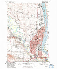
1992 Map of Richland
USGS Topo · Published 1992About this map
The Hanford Site (D O E) dominates the northern landscape of this early 1990s survey, marking a period of transition for this nuclear production facility. To the south, the city of Richland and West Richland show significant residential and educational infrastructure, including the Washington State University (Tri Cities Campus) and numerous local schools like Carmichael Jr H S and Jason Lee Sch. The confluence of the Yakima River and the Columbia River at Lake Wallula shapes the local geography, with the Mc Nary National Wildlife Refuge protecting the eastern banks.
Find a feature on this map
68 named features on this map. Tap any name to fly to it.
Don’t see what you’re looking for? This feature index may not catch every label — zoom into the map to look around manually.
Map Details
Editions of this 1992 Richland Map
This is the sole edition of this map. No revisions or reprints were ever made.
Other maps of this area

1917 · Pasco
USGS Topo · 1:125,000

1951 · Richland
USGS Topo · 1:62,500

1953 · Walla Walla
USGS Topo · 1:250,000

1958 · Walla Walla
USGS Topo · 1:250,000

1964 · Kennewick
USGS Topo · 1:24,000

1964 · Pasco
USGS Topo · 1:62,500

1965 · Eltopia
USGS Topo · 1:62,500
1965 · Weber Canyon
USGS Topo · 1:24,000
1965 · Badger Mtn
USGS Topo · 1:24,000
1965 · Badger Mtn
USGS Topo · 1:62,500